
Signposts
When Eileen and I first started walking the magnificent mountains of Gran Canaria almost 20 years ago, there were virtually no signposts at all, except for a few home-made signs, a few coloured dots on some rocks and some stone cairns. In La Palma, La Gomera and Tenerife there were signs, but these three islands are all in the province of Tenerife. In the last few years, the province of Gran Canaria has also realised the importance of good signposts and maps. They have also probably realised the importance financially of rural tourism and hiking in general.
About 10 years ago the signposts for paths and routes such as the PR GC 60, PR GC 80, PR GC 01 started to appear, soon to be followed by several county councils signing routes in their own areas in a rather un co-ordinated fashion. Counties such as Artenara, Valsequillo and Santa Lucia, did quite a good job, a few of these old signs still exist. There was very little information made available to the public about any of these routes.

In May 2013 we spotted the first of the latest generation of signs, such as the S 70 and S 85. S stands for Sendero meaning hiking path. About half a dozen routes had these new sings in the central area (known as the Cumbre). We noticed several old footpaths being restored around the same time and now most of these paths have been signposted also. During the Autumn of 2013 a few more routes appeared in the SW, such as the S 50 and S 57, and in the Summer of 2014 many new signposts were erected, the signs/arrows actually joined the posts in the Autumn. The Artenara and Tamadaba area received many news signs as did the Teror/San Mateo area, to be followed by the area around the major lakes in the south of Gran Canaria (Chira, Soria and Las Ninas).

There are now too many new signs to list, but in Volume 2 of my walking guide I have listed the new signposted routes, in each of the 5 zones that I have split Gran Canaria into, to help put together longer walks for the more experienced walkers. In early 2015 a few more signs appeared, but in the spring of 2015 good maps such as the one below began to appear. Unfortunately there is at present no information available to the public to accompany these maps or the new sings in general, no web site, no contact phone number etc. We have so far found 12 of these maps in different locations, there are 3 different maps at Cruz de Tejeda, we are sure we have more of them to discover.
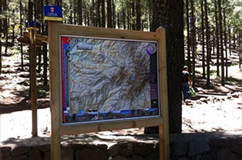
The map below is at Llanos de la Pez, a picnic area in the Cumbre, on the S 51, the dark stripe on the right of the map lists the numbered trails in this area.
As well as the "S" there are also some SL routes, these are “Senderos Locales”, local routes usually just covering one county. You will find that many counties will have an SL 1, SL 2, etc. but with nothing on them to indicate which county you are in. I usually put these on my maps just as SL, numbering them would make things too complicated as different counties have different ideas about how to number their routes.
At first we found a few signposts with incorrect information, these have been corrected, at present I am pleased to say that I have not personally seen any signpost with incorrect directional information, a few of the distances are debatable. This work is still ongoing, very popular walking areas such as Guayadeque, Santa Lucia, and the Mount Tauro area in the SW are still waiting to be signposted. I hope that in the next year or so these areas will also have many signposts and maps to accompany them.
In between the main signposts there are what I call “finger posts”, the photos show a “yellow” and “green” finger post. These usually have an angled top to indicate the direction you should head, but usually only in one direction, all routes are possible in both directions. There are no numbers on these posts and in my opinion are too infrequent. There are also on occasions a yellow or green painted stripe on a rock to help your navigation.

These are on the longer “S” routes

These are on local routes
With the new Discovery Walking Guides map and all of the new signposts a few hikers have tried to use this information without purchasing my guides. We have had several people come to us to purchase either the PDF or printed guides as they have found they cannot achieve many good routes without an accurate narrative, especially if it is their first time walking in Gran Canaria.
A typical example is the S 47 from Santa Lucia to Fataga - the first S 47 sign from Santa Lucia Church is good, the 2nd sign is also good informing you to cross the road in front of the small supermarket ”Perez Ortega”, 25 metres later there is no sign at all telling you to turn right, so most people continue straight on and get lost before leaving Santa Lucia!!!! Later on the signposts are very vague as you cross Las Tirajanas Barranco, again there are not enough intermediate finger posts. The route chosen for the S 47 differs from my route which passes through some “hippy” houses. The signpost in Fataga pointing to Santa Lucia lasted one day before a lorry reversed into it, this sign has now been modified and replaced.
The local authorities have done a good job signposting many routes, but there is still nothing available that a hikers can actually take with them on these routes. Unlike my guides there are no downloadable GPX tracks. There is still a lack of intermediate markers between the main signposts, and a few very popular walking areas in the south still waiting for new signposts. Some of the new routes have been restored, there are now often good stone built entrances to the hiking paths, we have to wait and see how these routes are maintained, already I have received comments about certain signposted routes needing some urgent maintenance.
Work on signposting routes is still ongoing, I expect to see many more new signposts in the next few months - these will be mentioned on the Updates page of this website. The authorities here have not made any information about these new routes available to the public yet, although some good maps are now appearing on a few of the signposted routes, all you need is a photographic memory.
In the notes for the hikes in my guides I always try to use signposted routes, unless I know a better or more interesting alternative. An example of this is the S 90 in Artenara which misses out a cave church and an excellent cave museum. If you have purchased my guides and find any new signposts that are not mentioned please send me details of the sign and the location, with GPS co-ordinates if possible.
Please note that both on the DWG map and in my walking notes names of the Villages, Degolladas etc. that have been used are the names given on the official (Cabildo) signposts. There are other maps etc. that use different names. For example Degollada de Tasarte is named as Degollada del Aldea on some other maps. If you do find any differences between the official signposts and the DWG map and/or our walking notes please let me know by e-mail at
 Don't Leave Gran Canaria Without Seeing It..
