Vol1 - The Shorter Options
Volume 1 - The Shorter Options Guide has been written to help any visitor to Gran Canaria to investigate and discover the fascinating interior of the island.
Many visitors comment on the lack of history and culture in the touristic resorts, the reason being that almost no-one lived in this area until mainstream tourism arrived about 50 years ago. Those visitors who explore the centre and north of Gran Canaria will find a wealth of things of interest, such as villages of occupied cave houses, small museums run by local people, large reservoirs and many impressive churches, usually surrounded by attractive and peaceful plazas.
When I started to write this 'book' it started out as just a hiking guide, but soon developed in to something much more.
There are 35 hiking routes, mostly from 2 hours 30 minutes to 3 hours 30 minutes with a maximum ascent of 500m, with full instructions, GPS waypoints, detailed maps, instructions of how to get to the start etc.
Of these 35 walks 20 are circular and 15 are linear, with full details of how to return after the walk. There are also over 30 there-and-back walks spread around the island. All of these routes are shorter than the routes in Volume 2 'The Longer Options' Guide.
In this Volume 1 'The Shorter Options' Guide, I have split the island into 5 Zones:
- Zone A
- - is the South West including Arguineguin, Puerto Rico, Mogan and La Aldea de San Nicholas.
- Zone B
- - is the South East including Maspalomas, San Bartolome, Santa Lucia, Aguimes and Ingenio.
- Zone C
- - is the North East including Las Palmas, Teror, Arucas and much more.
- Zone D
- - is the North West including Artenara, Galdar, Guia and Agaete.
- Zone E
- - is the Centre (known as the Cumbre) including Pico de las Nieves, Roque Nublo, Tejeda and San Mateo.
Each zone has between 5 to 9 walks with full information, and short circular walks as well as lots of information about what to see and do in each area.
All the main 35 walks include a map of your route and all of these maps now use the Discovery Walking guides map of Gran Canaria as their base map. The 2015/2016 version is the first edition to use these maps, this work has been done with permission from Discovery Walking Guides.
There is a suggested best walk in each area, and for those who prefer to investigate by car a suggested most interesting drive and also a suggested best day out in each zone.
Volume 1 'The Shorter Options' Guide has 20 circular and 15 routes from A to B with the local bus times included. All of these walks have full GPS information. There are also over 30 there-and-back walks, all of these walks are designed to be half day hikes.
This Guide also includes lots of local information of what to see and do in the many rural villages and towns, with suggestions of where to stop and enjoy local specialities.
The 2 guides have been designed to complement each other with all the local information being in Volume 1, and the longer and more demanding walks in Volume 2. The walks in this guide, Volume 1, are from grade 2.5 to 5, some of the shorter there and back walks would be lower.
Both Rambling Roger's Guides are available in Printed or PDF version.
Also mentioned are the best attractions on each part of the island, both natural and man-made. I also recommend the best rural hotels, and other rural accommodation. Gran Canaria really does live up to its nickname as a "Continent in Miniature”.
I would recommend at least one visit to each of the 5 Zones, the North East area will need more than 1 visit as there is more than enough to see in the capital city of Las Palmas to fill 1 day.
This Guide is designed to help everyone who wishes to see the real Gran Canaria discover how much variety there is on a relatively small island. In each one of these 5 zones there are many things to discover and investigate.
As I am a local resident, items are updated much more often than other commercial guide books.
Extracts from the Guide
Below is an example of the information you will find in the various Zones. This information is about Fataga, in Zone B the South East. Fataga is situated on the GC 60 about 12 miles or 20 Km inland from Maspalomas, and is in the county of San Bartolome. It is a very attractive hilltop village, about 600 metres (2,000 feet) above sea level.
The GC 60 is almost a village bypass, as most of the village has just footpaths connecting the houses together. There has been a settlement here for about 2,000 years, mostly due to a natural spring ( Fuente Grande ) just north of the village. The Fataga Barranco is known as the valley of a thousand palms.

In the village there are some bars and restaurants, a petrol station, a bakery, a couple of souvenir shops and an art gallery.
It is well worth parking near the village church, San Jose which dates back to 1880, and investigating the side streets behind the church plaza with its shady laurel trees, see if you can find the old laundrette.
Fataga was a self sufficient community, which thrived on agriculture before tourism became the main industry about 50 years ago, the GC 60 was only a dirt road until the mid 1970's.
Potatoes are now the main crop grown in the fields, and Fataga has the Fiesta of the Apricot in early summer each year. There are several small Bodegas in the village and some casas rurales ( rural houses for rent ). As in many rural locations the local population has halved in the last century. There is a water mill ( not working ) just north of the village, in the grounds of the Molino del Agua rural hotel which has been recently restored.
There are only a few good walks in this area at present, due to poor maintenance of the local camino reales, but there are good walks from San Bartolome to Fataga and Santa Lucia to Fataga.
Roque Nublo short route:
Approx walking time 1 hour, 30 minutes. Altitude approx 1590m
Start and finish GPS co-ordinates: North 28° 57.950' / West 15°.36.100'
Park at the Roque Nublo car park (known as La Goleta) on the GC 600. Walk up the signposted route (S 70 to Roque Nublo) for approx 15 minutes, then turn right at a signposted Y junction.
Follow this path until the next signposted junction (S 70 to El Aserredor) where you bear left. Continue on this delightful path, which contours around a hillside, with excellent views to your right until the next signposted junction about 10 minutes later.
Turn left uphill here, signposted (S 70 to Roque Nublo) the rocky path is steep in places and in about 10 minutes you emerge at a small plateau, this is Degollada del Nublo. Turn left here, then bear right to soon ascend some rocky steps up to a larger plateau, this leads to Roque Nublo itself.
After enjoying the excellent views return to Degollada del Nublo, this time bear left and take the descending signposted S 70 footpath to La Goleta. Take care with the first part of the descent it is rather slippery. Continue onto the next junction to bear right to walk in the reverse direction on the path you walked earlier. This walk is suitable for all sure footed hikers, and should take about 1 hour 30 minutes in total, it could well be described as a family walk.
The map in walk 32 of the full Volume 1 'The Shorter Options' Guide shows more details.
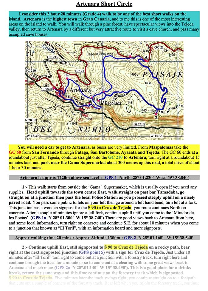
Below is an example of a walk that is typical of the hikes you will find in this Guide. This complete walk is FREE and is a great example of the quality of walks you will find on Gran Canaria. *Please note - this walk is not in my Guide - this is a free extra walk.. I hope you enjoy it and will want to purchase my walking guide to do many more great hikes here.
All the mountain walks in my Volume 1 'The Shorter Options' Guide fit onto 2 sides of A4 paper. The walk is titled and a brief overview of the walk is given, including its grade and length, also a map indicating the route and also the part of the island where the walk is situated.
My Guide also includes how to get to the start of the walk and how to get home afterwards, including suggested driving route, bus times etc.
GPS waypoints are given for all major junctions, the best viewing points, items of interest, the most important heights are also included.
The time of each stage and the cumulative time of the walk is stated, as well as the conditions underfoot. Compass directions are given as necessary, as are public toilets, suggested picnic stops, shops and restaurants etc. Also included are the cumulative totals for the complete walk at the end of the notes.
Please find below, an example of typical information you will find in my walking Guide - including directions, pictures and map (the PDF document shows the exact layout).
Example page - The Artenara Short Circle - North West

Download Free Walk - The Artenara Short Circle > *IMPORTANT NOTICE ! (October 2019) - this walk cannot be accessed at the moment due to fire damage.